
Port Orford Gap Filler Annex Radar Site
U.S. Air Force
During the Cold War, especially the late 1950s, there was great concern for the security of North American airspace. The U.S. Air Force, the American component of the joint U.S.-Canada North American Air Defense Command (NORAD), deployed a series of radars around the periphery of the United States to detect inbound aircraft, and later inbound missiles. While these radar sites provided good coverage, the technology of the time did not provide total coverage. In areas where it was thought enemy aircraft could fly low to avoid detection by the longer-range radars of the permanent and mobile radar networks, AN/FPS-14 and AN/FPS-18 “gap filler” radars were placed in unmanned Gap Filler Annex (GFA) locations. Over 130 of these radars, with detection range of about 65 miles, were positioned around the country.

"One if by Land, Two if by Sea"
The primary air defense site for the southern Oregon coast was the 761st Radar Squadron at what was called North Bend Air Force Station (AFS). North Bend AFS and its profusion of long-range radars was actually located on a promontory east of Hauser. North Bend was known to Air Force interceptor pilots by its callsign “Goodbook.”
Although North Bend AFS’s location provided good coverage of the western approaches to the Oregon coast, it was believed that the area from Crescent City to North Bend required additional detection capability. To provide total coverage, a GFA site was constructed at the existent U.S. Coast Guard Port Orford Lifeboat Station.
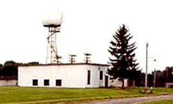
Port Orford GFA Site, with site designator P-12A, was equipped with an AN/FPS-14 radar and L-shaped concrete equipment building, similar to that shown here. (Photo courtesy Tom Page, Online Air Defense Radar Museum historian)
The GFA radar at Port Orford was unmanned – its signal was fed to North Bend (site P-12) where it was combined with North Bend AFS’s long range radars and two other GFA radars to provide a comprehensive picture of the southern Oregon coast. The other two were AN/FPS-18 GFA radars at Disston (site P-12B) and Placer/King Mountain (site P-12C).
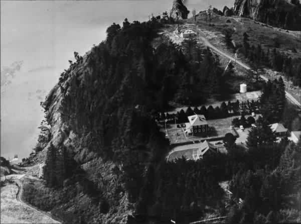
The radar site, operational from 1957 to 1967, is easily seen in this photo of the site from around 1960. The radar complex is located at the end of the access road that runs above the Coast Guard crew quarters and operations area.
The site was considered operational until December 1967. With the advent of better radars and communications systems, the numerous radar squadrons and GFA sites were no longer needed. Today, all West Coast air defense intercepts are controlled from the Western Air Defense Sector at McChord Air Force Base in Tacoma, Washington.

Here is the area as it appears today. A recent visitor to the site writes:
Regarding the access road to the site of “the Old Gap Filler Radar”
at Port Orford, my wife and I walked out to the site yesterday. We found several
holes with remains of the concrete footing, re-bar, some electrical conduit and a
small iron truss. The roadway is particularly obscured by encroaching brush;
therefore, not open to vehicular traffic. However, it is easily accessible from
the Coast Guard Barracks Building by following the concrete walkway until it
intersects with the old roadbed. Go left on the old roadbed about 150 feet
to the “site”.
Acknowledgement: Portions from the Radomes, Inc, online museum, a U.S. Air Force veterans organization that preserves the history of the Cold War era air and missile defense of the North American continent. We applaud and support their efforts.
